Ateneo Physics Faculty Dr. Quirino Sugon Jr attends the 2015 UN/Japan Workshop on Space Weather
June 8, 2015 1 Comment
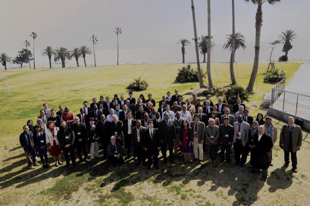
Participants in the 2015 UN/Japan Workshop on Space Weather held at Luigans Hotel, Fukuoka City, Japan. (Photo by ICSWSE posted in Twitter)
Last 2-6 March 2015, Dr. Quirino Sugon Jr, Assistant Professor of the Department of Physics, attended the United Nations/Japan Worshop on Space Weather in Fukuoka, Japan. This 5-day workshop at Luigans Hotel in Fukuoka is about Science and Data Products from ISWI instruments. ISWI is the International Space Weather Initiative, which was part of the 2010-2012 workplan of the United Nations Committee on the Peaceful Uses of Outer Space (UNCOPUOS). ISWI is a collaboration of different instrument arrays for the understanding of the impact of solar activity on Earth. One of these instrument networks is the MAGDAS (Magnetic Data Acquisition System) network, which consists of 72 magnetometers worldwide, with 6 of them in the Philippines (TGG, LGZ, MUT, CEB, CDO, and DAV). In 2012, ISWI led to the creation of ICSWSE (International Center for Space Weather Science and Education) in Kyushu University. The ICSWSE subcenter is at the Ionosphere Research Building of Manila Observatory. As the program head of Manila Observatory’s (UAD) Upper Atmosphere Dynamics program, Dr. Sugon also coordinates the activities of the ICSWSE subcenter and those of the other MAGDAS stations in the Philippines.
Below is an interview with Dr. Sugon by Ateneo Physics News:

The research team of Upper Atmosphere Dynamics program of Manila Observatory: Clint Bennett, Christine Chan, and Dr. Quirino Sugon Jr.
1. How long have you been attending ISWI-related activities?
In 2010 I attended the 1st ISWI Workshop in Helwan University, Egypt. In 2012, I attended the MAGDAS/ISWI School on Space Weather in Bandung, Indonesia, together with my co-faculty, Mr. Clint Bennett. This 2015, Clint Bennett and Fr. Daniel J. McNamara were also both invited to join the UN/Japan Space Weather workshop in Fukuoka, Japan, but Fr. Dan has a visa problem while Clint got sick a few days before his flight to Japan. So I left for Japan alone.
My attendance to the ISWI workshops was made possible because of our collaboration with ICSWSE. In 2008, Prof. Kiyohumi Yumoto of SERC (former name of ICSWSE) and Executive Director Antonia Yulo-Loyzaga of MO (Manila Observatory) signed a Memorandum of Agreement which led to the establishment of MO’s Ionosphere Research Building as the SERC subcenter (now ICSWSE Subcenter). In all three workshops, ICSWSE funded my trips.

Dr. Quirino Sugon Jr. presenting his poster on Equatorial Electrojet measurements in the Philippines
2. Did you present a research at the workshop?
I presented a poster on the measurement of the height, strength, and length of equatorial electrojet (EEJ) currents in the ionosphere using MAGDAS magnetometer data. These currents produce a magnetic field around them which can be measured on the ground, and from these measurements we can deduce the the properties of these electrojets, after filtering out the background geomagnetic field. The theoretical framework is simply Biot-Savart law, which is taught sophomore physics and engineering majors, e.g. Young and Freedman’s University Physics. What is new maybe is our assumption that the jets are not infinitely long linear currents as assumed by Chapman, but only of finite length, as shown, for example, in magnetohydrodynamic simulations illustrated in the Wikipedia article on the EEJ.
These equatorial electrojets were already measured by Jesuit Fathers in Manila Observatory in their magnetometer stations in Manila and Antipolo more than 100 years ago. The Jesuits produced tables of magnetometer values in H (horizontal), D (declination), and Z (vertical) every hour of the day. So my presentation in the UN/Japan workshop is a continuation of this long Jesuit tradition in space weather research at Manila Observatory.
My research team at Manila Observatory consists of my co-faculty Clint Bennett and Research Assistant, Christine Chan. Clint made the first measurements of the equatorial electrojet current height, strength, and length by analyzing MAGDAS CEB data using Matlab. We presented the results of his work in a poster at the AOGS (Asia Oceania Geosciences Society) conference in Sapporo, Japan last 2014. Christine continued Clint’s work, but this time she coded in Python and added two more stations: CDO and LGZ. The results are still the same: the electrojet is about 1,000 km from the ground at the dip equator near Davao (where the vertical component of the geomagnetic field is nearly zero), with strengths of about 1 Ampere, and lengths of about 1,500 km. These jets follow a diurnal variation, which peaks at around 1 pm local time.
Our results of 1,000 km electrojet height is troubling, because the accepted values in the literature is only about 100 km. Perhaps, there is something different about the Philippine electrojets which is responsible for the 1,000 km heights. Perhaps, we have not yet considered the curvature of the earth. The analytical computation of the magnetic field of a finite circular current arc was already done before by another author, but the integrals are a bit tough. Perhaps we have not yet considered the magnetic field produced by the ground induced currents (GIC), which are currents produced by the changing magnetic field produced by the electrojets, as described by Faraday’s Law. Perhaps, some electromagnetic shielding happens in the lower ionosphere, which distorts the magnetic field produced by the electrojet currents. Perhaps, the electrojets are not infinitesimal but have spatially varying finite widths and heights. We’ll consider these possibilities one by one in order to gain a better picture of the motion of the equatorial electrojets.

Equatorial Electrojet (EEJ). Source: Wikipedia.
3. Why should we care about equatorial electrojets and space weather?
Equatorial electrojets are similar to the auroral electrojets: in both cases the currents move in circles perpendicular to the geomagnetic field and they occur daily due to the rotation of the earth and the difference in ion production between the earth’s day and night sides. The auroral electrojets are not the same as the dazzling auroras at the polar countries, which only happen during geomagnetic storms. But electrojets and auroras are similar in that they are due to the motion of electrical charges.
On a more serious note, geomagnetic storms are becoming more dangerous the more we rely on satellite-based global navigation systems such as GPS for cars and airplanes. As you perhaps know, position information is determined using the sending and arrival times of signals from at least 4 GPS satellites. Signals which take a long time to reach you are farther than those which took a shorter time to reach you. Multiply the time difference between the time the signal left the satellite and the time it reached the receiver by the speed of light (about 3×10^8 m/s) and you get the satellite-to-receiver distance in kilometers. If you only have one satellite, you only know that you are within a particular spherical radius from a satellite. If you have two satellites, you know your position lies somewhere in circle which is the intersection of the two spheres of possible distances. If you have three satellites, you know that your position is one of two possible points (intersection of thre spheres of possible distances). If you have four satellites, you can be finally sure where you are, and this is how the GPS works.
Now, if there is a geomagnetic storm, the earth’s magnetic field becomes disturbed, which in turn disturbs the ionosphere. Since the ionosphere lies between you and the GPS satellites, the satellite signals would be severely affected. Remember that satellite signals are electromagnetic waves and the ionosphere consists of charges which are affected by electric and magnetic fields. When the satellite signal passes through the ionosphere, its path becomes reflected or refracted (bent) in the same way as when you shine a flash light in a glass plate, but with different colors or frequencies affected more than others. It is possible to remove the effects of the ionosphere by using the travel time of two different frequencies sent by satellites at the L1 and L2 bands (their wavelengths are the length and width of your iPad!). But this removal of ionospheric effects is only possible if we make certain assumptions about the ionosphere, e.g. horizontally stratified and static. So during geomagnetic storms which can last for several hours, these assumptions about the ionosphere fail and no algorithm can help us deduce our position from the GPS satellites. Filipino sailors may not really worry about this, since they were trained to determine their latitude and longitude positions from the positions of the sun and stars. But sailors and pilots who rely exclusively on GPS would be at loss. This is particularly true in the polar region: during geomagnetic storms, pilots are advised to avoid the poles and take alternative routes. Airplanes which got lost during geomagnetic storms may find themselves straying in hostile territory and may get shot down by missiles for being mistaken as fighter jets or spy planes.

Prof. Akimasa Yoshikawa and Dr. Quirino Sugon Jr. Prof. Yoshika is the Principal Investigator of the MAGDAS Project of ICSWSE, Kyushu University, Japan.
4. Is there a relationship between geomagnetic storms and ordinary storms such as typhoons or cyclones?
At present there is no known direct relationship between geomagnetic storms and ordinary storms. So the relationship between the two storms is is only by mathematical analogy.
If you are on the ground and a typhoon passes by, you only know how strong is the wind and how the air pressure drops. But if you have an array of about stations measuring wind speed, wind direction, and air pressure, together with a mathematical model of a typhoon, you can determine where the eye of the storm is, plot its course, and warn the citizens of the impending danger, as what Fr. Federico Faura, SJ of Manila Observatory have done more than a hundred years ago.
Similarly, if you are on the ground and a geomagnetic storm happens, all you see is are large oscillations in your magnetic data, and you can’t be sure whether these oscillations are due to geomagnetic storms or to electric trains, as what happened in the 1900’s when Manila Observatory in Manila was forced to relocate its magnetic station to Antipolo because the newly installed electric trains were disturbing the magnetic measurements. If you have several magnetic stations in the whole Philippines as what we have now, you can isolate local effects, such as from electric trains, from geomagnetic storms. But to find the eye of the of the geomagnetic storm so to speak, you have to look far into space into the sun.
Right now, there are two STEREO satellites orbiting around the sun, which allows us to see the 3D structure of the sun in the same way as our two eyes allow us to gauge distances of objects using triangulation. In the sun are sunspots, which look like small dots from our vantage point, but some of them may be the size of the earth. Actually, you can think of sunspots as typhoons or cyclones in the sun; the only difference is that instead of air currents and gravitational field, you have charged particles (plasma) under both the sun’s gravitational and magnetic fields.
Sometimes, the sun erupts like a volcano and vomits blobs of plasma into space called Coronal Mass Ejections. These blobs of plasma have magnetic field locked into them. How these plasma affects the earth depends on the direction of the plasma’s magnetic field, which is also known as the Interplanetary Magnetic Field (IMF). Since the earth’s magnetic field is pointing from Geographic South to Geographic North (Northward), then the earth’s magnetic field would be affected by a Southward magnetic field of the plasma. The earth’s magnetic field ripples due to the shock and the magnetotail reconnects. Then a part of the magnetic field flies out into space resulting to the injection of charges in the magnetosphere and the formation of auroras.
5. Are there signals no. 1, 2, and 3 for geomagnetic storms in the same way as what we have for typhoons?
Geomagnetic storms can be measured in a scale. One way is to define the storm in terms of the fluctuations of the geomagnetic field, e.g. Bartel’s K-index. Depending on the location of the magnetic station, the fluctuations can differ, so some kind of calibration is used in order to compare the values of different stations. But if we are more interested on the effects of the geomagnetic storm, NOAA proposed another scale called the G-scale. Here are the two extremes:
G1. Minor. Power systems: Weak power grid fluctuations can occur. Spacecraft operations: Minor impact on satellite operations possible. Other systems: Migratory animals are affected at this and higher levels; aurora is commonly visible at high latitudes (northern Michigan and Maine).
G5. Power systems: Widespread voltage control problems and protective system problems can occur, some grid systems may experience complete collapse or blackouts. Transformers may experience damage. Spacecraft operations: May experience extensive surface charging, problems with orientation, uplink/downlink and tracking satellites. Other systems: Pipeline currents can reach hundreds of amps, HF (high frequency) radio propagation may be impossible in many areas for one to two days, satellite navigation may be degraded for days, low-frequency radio navigation can be out for hours, and aurora has been seen as low as Florida and southern Texas (typically 40° geomagnetic lat.).

Dr. Quirino Sugon Jr with the staff of ICSWSE, Kyushu University, Japan: Dr. Akiko Fujimoto (left) and Dr. Grace Cardinal Rolusta (center). Dr. Rolusta used to work at the Manila Observatory under Fr. Sergio Su, SJ’s Solid Earth Dynamics program.
6. Can Philippine electrical power grids be affected by geomagnetic storms?
There is no study yet for the Philippines. But here’s is what happened to Quebec during the March 9, 1989 geomagnetic storm (Wikipedia):
The variations in the earth’s magnetic field also tripped circuit breakers on Hydro-Québec’s power grid. The utility’s very long transmission lines and the fact that most of Quebec sits on a large rock shield prevented current flowing through the earth, finding a less resistant path along the 735 kV power lines.[8]
The James Bay network went offline in less than 90 seconds, giving Quebec its second massive blackout in 11 months.[9] The power failure lasted nine hours and forced the company to implement various mitigation strategies, including raising the trip level, installing series compensation on ultra high voltage lines and upgrading various monitoring and operational procedures. Other utilities in North America and Northern Europe and elsewhere implemented programs to reduce the risks associated with geomagnetically induced currents.[8]
One way to determine if geomagnetic storms affect the Philippine power grid is to list all the occurrences of power failures, e.g. transformer breakdowns, their dates, times, and locations for an 11-year period, which corresponds to one solar cycle. Then we make another list of geomagnetic storms according to NOAA G-scale for this period. If we see that many power failures come within a day or two of the occurrence of the geomagnetic storm, then geomagnetic storms may indeed cause many of these power failures.

A tour of the Marine World near Luigans Hotel, Fukuoka City, Japan.
7. Did you visit other places in Fukuoka?
I was not able to join the tour around the city. But near Luigans hotel is the Marine World. In this building is an amphitheater for the dolphin show. You see a pool below where the dolphins jump up and down on the water, sometimes they soar in pairs to great heights in order to reach a red ball in the ceiling, and then they fall back with a splash on the pool. Across the pool is the sea, which stretches far into the horizon, and to the sky.
The Marine world is like a labyrinth glass tunnel inside a giant aquarium. It is fascinating to see fishes and other sea creatures in their near-natural habitat. I see the octopus, the shark, the turtle, and many small, brightly colored fishes. So this must be what it is to live like Aquaman in the great city Atlantis, with all these sea creatures at your call. Or perhaps like Captain Nemo in his submarine 20,000 leagues under the sea. Or perhaps like the Little Mermaid. And like the Little Mermaid, I feel in my heart that I do not really belong here, for a much more beautiful world is not down here but up there, and to live is to walk on land, breathe the air, and be with the love of your life. Perhaps, the whole universe is just one giant aquarium after and we do not really belong here. And someone who loves us awaits us far beyond the clouds, far beyond the sun, far beyond the stars.

Prof. Kiyohumi Yumoto gives a speech while Prof. Akimasa Yoshikawa and Ms. Kayo Goto helps him in the podium.
8. What was your most memorable moment at the conference?
During the last day and hour of the conference, Prof. Kiyohumi Yumoto came to the podium with halting steps, accompanied by members of the ICSWSE: Prof. Akimasa Yoshikawa, Engr. George Maeda, and Ms. Kayo Goto. His fingers were shaking as he held before him a piece of paper containing a few sentences:
“I am sorry. I had a stroke. I can’t remember many things. I would like to thank my wife for taking care of me.”
He repeated his speech thrice. Then everyone stood and clapped their hands for a long, long time. Here is a man who installed his first flux gate magnetometer system in 1990, which has grown in 2015 into a world wide network of more than 72 magnetometers and 3 FMCW radars, with 6 of these magnetometers stationed in the Philippines and one of these FMCW radars hosted in Manila Observatory. Here is a man who used to stride the world like a Colossus, meeting scientists from different continents to seek partners and collaborators, and inspire the next generation of students to pursue big science. And here he is now on a wheelchair, with much of his past memories he can barely retrieve from his brain. But we love him, because we remember.
Indeed, science, for all its abstractions and mathematical formulas, is still a human endeavor. A man can do only so much as a scientist, but in the end it is relationships that really matter.
 Entrance of Hotel Luigans, Fukuoka City, Japan. Photo by Quirino Sugon Jr. |
 Facade of Hotel Luigans facing the sea in Fukuoka City, Japan. Photo by Quirino Sugon Jr. |


, Dr. Jerrold Garcia, Dr. Adrian Serohijos, and Dr. Nina Rosario Rojas")


